

quentinrey
-
Compteur de contenus
2719 -
Inscription
-
Dernière visite
-
Jours gagnés
3
Type de contenu
Profils
Forums
Calendrier
Tout ce qui a été posté par quentinrey
-
 Super reportage ! Très belle soirée que celle du 12 au 13 !
 -
Suivi du temps dans les régions méditerranéennes septembre 2018
quentinrey a répondu à un sujet de MP84120 dans Le temps en France
Mmh, je vais peut-être penser à aller faire un plouf dans la semaine à ce rythme ! 😎 -
Suivi du temps dans les régions méditerranéennes septembre 2018
quentinrey a répondu à un sujet de MP84120 dans Le temps en France
Quand dame nature t'offre un beau début de semaine : Source de la photo : Romain Petit Je ne sais pas si d'autres personnes les ont photographiées ? -
Suivi de l'ouragan Florence
quentinrey a répondu à un sujet de stormsnow59 dans Suivi des Phénomènes Cycloniques
Alors, beaucoup de fake sont diffusés. Mais est-ce fake ça ? -
Suivi de l'ouragan Florence
quentinrey a répondu à un sujet de stormsnow59 dans Suivi des Phénomènes Cycloniques
Ça me parait gros le ciel bleu ... Au satellite, toujours aussi sublime ! -
Suivi du typhon MANGKHUT _ septembre 2018
quentinrey a répondu à un sujet de dool dans Suivi des Phénomènes Cycloniques
Les images satellites sont vraiment exceptionnelles ici aussi ! Des webcams/comptes twitter à suivre pour cet événement (anglais ou français) ? 1 - Infrarouge 2- Heavy Rainfall potential areas -
Suivi de l'ouragan Florence
quentinrey a répondu à un sujet de stormsnow59 dans Suivi des Phénomènes Cycloniques
Concernant les médias, pour les médias américains il me semble logique qu'ils se focalisent, pour l'instant, sur Florence. En font-ils trop la bas, je ne pense pas. Pour ce qui est du traitement par les autres pays, dont la France, ils en font peut-être trop. Après je te rejoins sur le fait qu'on entende pas assez parler du Typhon Mangkhut, et qu'il mériterait son sujet sur le forum (rien que pour partager les images satellites ♥), mais en attendant : -
Prévisions régions méditerranéennes - Septembre 2018
quentinrey a répondu à un sujet de Vincent_L dans Prévisions à court et moyen terme
Bonjour ! Quelle évolution aux niveaux des modèles pour la possible dégradation de la semaine prochaine ? -
Suivi de l'ouragan Florence
quentinrey a répondu à un sujet de stormsnow59 dans Suivi des Phénomènes Cycloniques
Pour rappel, l'échelle de Saffir-Simpson (Catégorie 1, 2, 3, etc) est "graduée en cinq niveaux d'intensité, correspondant à des intervalles de vitesses de vents normalisés.". Il ne faut donc pas oublier les autres effets, parfois dévastateurs, que sont la pluie, la montée des eaux (marée + onde de tempête si je ne dis pas de bêtises), et ce en plus du vent ! Il suffit de voir les réseaux sociaux, notamment Twitter, pour suivre les événements et voir que c'est déjà tendu, et que ce n'est pas finis ! Allez, au passage deux images satellites (GeoColor + Infrarouge) -
Suivi du temps dans les régions méditerranéennes septembre 2018
quentinrey a répondu à un sujet de MP84120 dans Le temps en France
Ah nan mais cette année c'est la folie je trouve, je me fais bouffer tous les soirs par ces sal****ies de moustiques tigres ! Je suis plus souvent en chasse aux moustiques qu'en chasse aux orages .. -
Suivi du temps dans les régions méditerranéennes septembre 2018
quentinrey a répondu à un sujet de MP84120 dans Le temps en France
Je pose ici quelques photos de la chasse de cette nuit ! Il a encore fait bien chaud aujourd'hui ! Bonne soirée -
Suivi de l'ouragan Florence
quentinrey a répondu à un sujet de stormsnow59 dans Suivi des Phénomènes Cycloniques
Petites images radar : Source : radar.weather.gov Le drapeau tient encore ! -
Suivi de l'ouragan Florence
quentinrey a répondu à un sujet de stormsnow59 dans Suivi des Phénomènes Cycloniques
Le jour se lève sur Florence ! Moins esthétique, avec un œil qui a perdu de sa beauté, l'ouragan reste conséquent par sa taille ! Le landfall est prévu pour cette nuit si je ne dis pas de bêtise, avec un possible renforcement avant ! A suivre avec les cameras et réseaux sociaux ! -
Déluge de foudre sur Trieste
quentinrey a répondu à un sujet de Christophe Suarez dans Photos, vidéos et matériel de prise de vue
Tes photos sont vraiment magnifiques ! La composition est top, je rêve de pouvoir photographier un orage en étant assez loin et un peu en altitude pour avoir ce rendu (même si d'autres paramètres rentrent en jeu évidemment) ! En tout cas bravo, super récit -
Sur la r'août'e orageuse 2018
quentinrey a répondu à un sujet de C.C. Chrispic dans Photos, vidéos et matériel de prise de vue
Ah ces photos quel bonheur ♥ On se suoviendra du 5 août et de cet impact proche dont je me souviens encore haha Quand à la soirée qui à suivi, un vrai moment de joie ! -
Suivi du temps dans les régions méditerranéennes septembre 2018
quentinrey a répondu à un sujet de MP84120 dans Le temps en France
Si ça pouvait remonter jusqu'ici 😇 En tout cas au radar c'est sympathique ! -
Suivi de l'ouragan Florence
quentinrey a répondu à un sujet de stormsnow59 dans Suivi des Phénomènes Cycloniques
Quoi qu'il en soit, c'est un vrai plaisir à suivre. Il faut espérer que tous les moyens ont été (et seront) employés pour éviter des morts. En tout cas les vidéos sont éloquentes. Exemple, l'organisation d'évacuations avec toutes les voies d'une route : Les images de queues dans les magasins sont également légion. Je ne connais pas assez le pays, mais au vu de ce que je vois sur les réseaux, la population est tout de même bien informée ! A elle de suivre les instructions maintenant ... Pour revenir à l'ouragan en lui même, encore une fois, les images satellites ♥ GOES GEOCOLOR Enfin, pour terminer, certains modèles voient l'ouragan stationner sur les terres pendant 48h (ça on verra avec le live ..) avant de remonter vers l'ouest. Il perdra de la puissance au fur et à mesure, mais certaines personnes s'inquiètent des possibles conséquences. Exemple : Je en connais que trop peu ces phénomènes, si certains s'y connaissent d'avantage et veulent bien faire une analyse, je suis preneur ! Bonne soirée ! -
Suivi de l'ouragan Florence
quentinrey a répondu à un sujet de stormsnow59 dans Suivi des Phénomènes Cycloniques
Même si ça date d'hier, ça reste à voir ! Timelapse d'un des vols de reconnaissance dans Florence ! https://twitter.com/NOAA_HurrHunter/status/1039521323654021120 -
Suivi de l'ouragan Florence
quentinrey a répondu à un sujet de stormsnow59 dans Suivi des Phénomènes Cycloniques
Si j'ai bien saisi, sensible baisse des vents au derniers passage de reconnaissance aérien. Cependant toujours de catégorie 4 et prévisions de renforcement d'ici demain ! Reports from an Air Force Reserve Unit hurricane hunter aircraft indicate that maximum sustained winds have decreased to near 130 mph (215 km/h) with higher gusts. However, Florence is still a category 4 hurricane on the Saffir-Simpson Hurricane Wind Scale. Re-strengthening is forecast to occur during the next day or so, and Florence is expected to be an extremely dangerous major hurricane through Thursday night. -
Saison cyclonique atlantique nord 2018
quentinrey a répondu à un sujet de cyco dans Suivi des Phénomènes Cycloniques
Le soleil se lève sur Florence ! L'imagerie satellite GOES est vraiment exceptionnelle je trouve !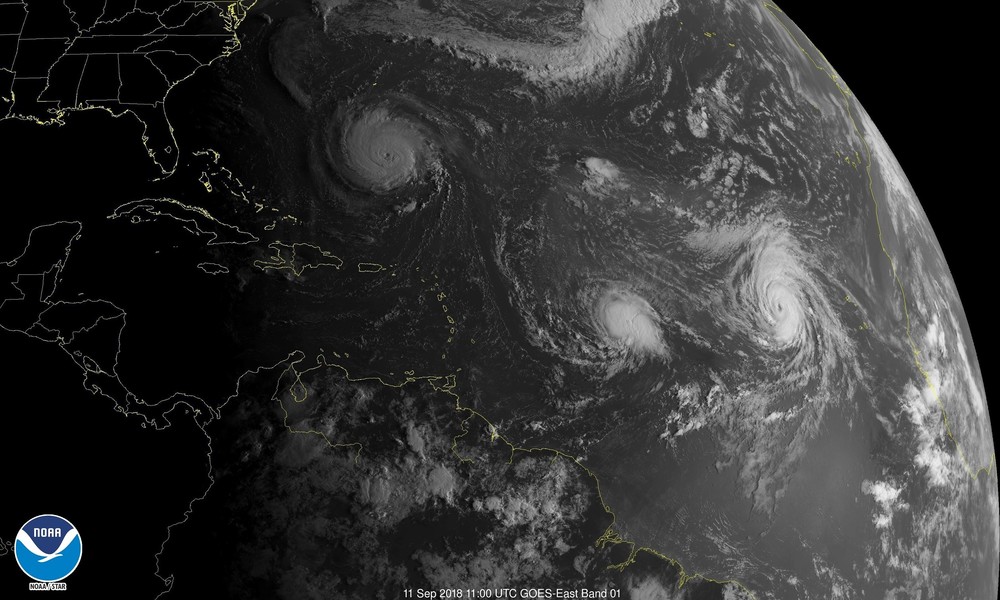
- 193 réponses
-
- 16
-

-
Suivi de l'ouragan Florence
quentinrey a répondu à un sujet de stormsnow59 dans Suivi des Phénomènes Cycloniques
Nouveau bulletin du matin par NHC WATCHES AND WARNINGS -------------------- CHANGES WITH THIS ADVISORY: A Storm Surge Watch has been issued for the east coast of the United States from Edisto Beach, South Carolina northward to the North Carolina-Virginia border, including the Pamlico and Albemarle Sounds. A Hurricane Watch has been issued for the east coast of the United States from Edisto Beach, South Carolina, northward to the North Carolina-Virginia border, including the Pamlico and Albemarle Sounds. SUMMARY OF WATCHES AND WARNINGS IN EFFECT: A Storm Surge Watch is in effect for... * Edisto Beach South Carolina to the North Carolina-Virginia border * Albemarle and Pamlico Sounds, including the Neuse and Pamlico Rivers A Hurricane Watch is in effect for... * Edisto Beach South Carolina to the North Carolina-Virginia border * Albemarle and Pamlico Sounds Interests elsewhere in the southeastern and mid-Atlantic states should monitor the progress of Florence. Additional watches may be required later today. A Storm Surge Watch means there is a possibility of life- threatening inundation, from rising water moving inland from the coastline, in the indicated locations during the next 48 hours. For a depiction of areas at risk, please see the National Weather Service Storm Surge Watch/Warning Graphic, available at hurricanes.gov. A Hurricane Watch means that hurricane conditions are possible within the watch area. A watch is typically issued 48 hours before the anticipated first occurrence of tropical-storm-force winds, conditions that make outside preparations difficult or dangerous. DISCUSSION AND OUTLOOK ---------------------- At 500 AM AST (0900 UTC), the center of Hurricane Florence was located near latitude 26.4 North, longitude 64.1 West. Florence is moving toward the west-northwest near 15 mph (24 km/h). A west- northwestward to northwestward motion with a slight increase in forward speed are expected during the next couple of days. On the forecast track, the center of Florence will move over the southwestern Atlantic Ocean between Bermuda and the Bahamas through Wednesday, and approach the coast of North Carolina or South Carolina on Thursday. Maximum sustained winds are near 140 mph (220 km/h) with higher gusts. Florence is a category 4 hurricane on the Saffir-Simpson Hurricane Wind Scale. Some strengthening is expected during the next day or so, and Florence is expected to be an extremely dangerous major hurricane through Thursday night. Hurricane-force winds extend outward up to 40 miles (65 km) from the center and tropical-storm-force winds extend outward up to 150 miles (240 km). The estimated minimum central pressure is 944 mb (27.88 inches). HAZARDS AFFECTING LAND ---------------------- STORM SURGE: The combination of a dangerous storm surge and the tide will cause normally dry areas near the coast to be flooded by rising waters moving inland from the shoreline. The water has the potential to reach the following heights above ground if peak surge occurs at the time of high tide... Edisto Beach to Murrells Inlet...2-4 ft Murrells Inlet to Cape Fear...4-6 ft Cape Fear to Cape Lookout including The Neuse and Pamlico River...6-12 ft Cape Lookout to Ocracoke Inlet...5-8 ft Ocracoke Inlet to North Carolina/Virginia Border...3-5 ft The deepest water will occur along the immediate coast in areas of onshore winds, where the surge will be accompanied by large and destructive waves. Surge-related flooding depends on the relative timing of the surge and the tidal cycle, and can vary greatly over short distances. For information specific to your area, please see products issued by your local National Weather Service forecast office. RAINFALL: Florence is expected to produce total rainfall accumulations of 15 to 20 inches with isolated maxima to 30 inches near Florence's track over portions of North Carolina, Virginia, and northern South Carolina through Saturday. This rainfall may produce life-threatening flash flooding. WIND: Hurricane conditions are possible within the watch area by late Thursday or Thursday night, with tropical storm conditions possible by Thursday morning. SURF: Swells generated by Florence are affecting Bermuda and portions of the U.S. East Coast. These swells are likely to cause life-threatening surf and rip current conditions. Please consult products from your local weather office. Les dernières images :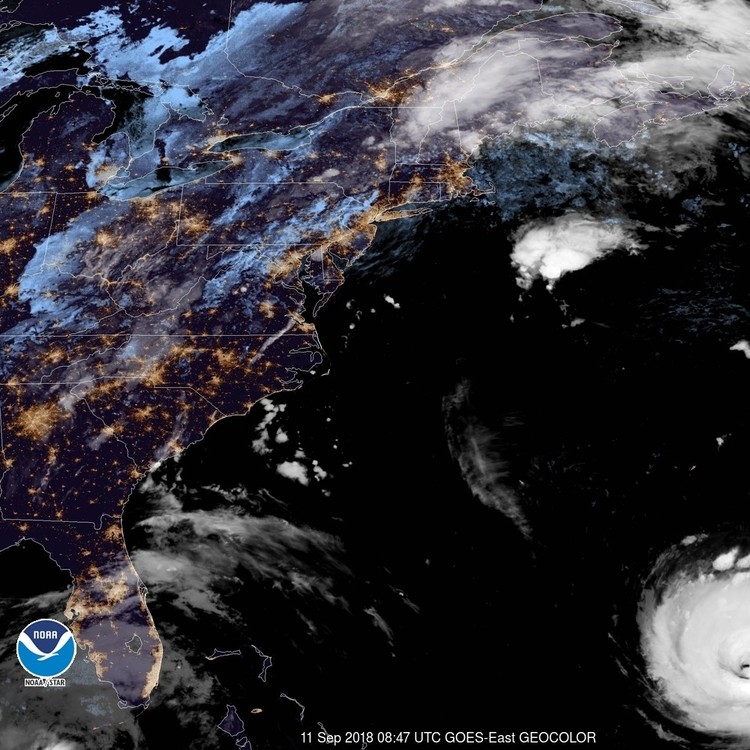
.thumb.jpg.f7a8847b6ff84db0fd0a4f89b1470818.jpg)
-
Saison cyclonique atlantique nord 2018
quentinrey a répondu à un sujet de cyco dans Suivi des Phénomènes Cycloniques
Les dernières images satellites GOES ♥ Source : nhc.noaa.gov EDIT : Evolutions prévues par plusieurs modèles. Certains voient un landfall en Cat.5. Probable selon vous ? On est encore "loin" mais en tout cas à suivre c'est quelque chose ! https://twitter.com/hurrtrackerapp/status/1039248806255243265 -
Suivi de l'ouragan Florence
quentinrey a répondu à un sujet de stormsnow59 dans Suivi des Phénomènes Cycloniques
Extrait du bulletin de 17h (11PM AM AST) DISCUSSION AND OUTLOOK ---------------------- At 1100 AM AST (1500 UTC), the eye of Hurricane Florence was located near latitude 25.0 North, longitude 60.0 West. Florence is moving toward the west near 13 mph (20 km/h). A west-northwestward motion with an increase in forward speed is expected during the next couple of days. A turn toward the northwest is forecast to occur late Wednesday night. On the forecast track, the center of Florence will move over the southwestern Atlantic Ocean between Bermuda and the Bahamas Tuesday and Wednesday, and approach the coast of South Carolina or North Carolina on Thursday. Satellite data indicate that maximum sustained winds have increased to near 115 mph (185 km/h) with higher gusts. Florence is a category 3 hurricane on the Saffir-Simpson Hurricane Wind Scale. Further strengthening is anticipated, and Florence is expected to be an extremely dangerous major hurricane through Thursday. Hurricane-force winds extend outward up to 30 miles (45 km) from the center and tropical-storm-force winds extend outward up to 140 miles (220 km). The estimated minimum central pressure is 962 mb (28.41 inches). Source : NHC.NOAA.GOUV -
Suivi du temps dans les régions méditerranéennes septembre 2018
quentinrey a répondu à un sujet de MP84120 dans Le temps en France
Au radar ça a l'air d'envoyer au sud du Gard la, dommage qu'il faille travailler haha -
Suivi du temps dans les régions méditerranéennes-Août 2018
quentinrey a répondu à un sujet de Serge L dans Le temps en France
Effectivement, belle bête ! (Qualité smartphone)


.jpg.6e9015b0a0feb240c1dfb02b7116462a.jpg)