Thundik81
-
Compteur de contenus
16 533 -
Inscription
-
Dernière visite
-
Jours gagnés
45
Type de contenu
Profils
Forums
Calendrier
Tout ce qui a été posté par Thundik81
-
FERLIR consacre son article du jour à Illahraun : https://ferlir.is/illahraun/ > ici c'est Járngerðarstaðir Différentes enquêtes topo : https://nafnid.is/baer/7942 Archéo (en GK-017) : https://skraning.minjastofnun.is/Verkefni_1382.pdf
-
Suite : https://www.resif.fr/blog/2023/11/10/etude-de-la-deformation-des-petits-seismes-en-metropole/
-
Et qui renvoie ce matin à l'excellent : https://www.visitreykjanes.is/en/volcano-eruption/eruption-news/earthquakes-temporarily-halt-operation-of-tourism-companies-in-the-svartsengi-area
-
Fermeture de chemin : https://www.almannavarnir.is/frettir/lokun-a-nordurljosavegi/ (voir aussi https://umferdin.is/landshluti/sudvesturland)
-
Autre sujet : https://www.mbl.is/frettir/innlent/2023/11/09/nyjar_myndir_syna_breytingar_hahitasvaedid_staekkar/ > https://www.youtube.com/watch?v=N5tCKu3HlDk
-
Traces au Þorbjörn des bons séismes du jour : https://www.ruv.is/frettir/innlent/2023-11-09-ummerki-eftir-storu-skjalftana-a-thorbirni-396142 > https://images.nyr.ruv.is/media/public/original_images/20231109_093846759_iOS.jpg https://images.nyr.ruv.is/media/public/original_images/thumbnail_20231107_101611.jpg https://images.nyr.ruv.is/media/public/original_images/thumbnail_20231109_151619.jpg https://images.nyr.ruv.is/media/public/original_images/thumbnail_20231109_151635_HDR.jpg
-
Ortho Express 2023 avec mise en ligne ce jour de la Haute-Savoie (RVB+IRC). Stépharve à l'agonie : https://www.geoportail.gouv.fr/carte?c=6.492239,46.022134&z=19&l0=ORTHOIMAGERY.ORTHOPHOTOS.IRC-EXPRESS.2023::GEOPORTAIL:OGC:WMTS(1)&l1=LIMITES_ADMINISTRATIVES_EXPRESS.LATEST::GEOPORTAIL:OGC:WMTS(0.55)&permalink=yes
-
Test de la carte tout à l'heure : https://vedur.is/photos/volcanoes/volcano_status.png Vegagerðin fait du suivi : https://www.vegagerdin.is/upplysingar-og-utgafa/frettir/stodug-voktun-vegna-jardhraeringanna Mais ils avaient promis de nouvelles webcams, et toujours rien (carte / page)
-
Nouvelles routes d'évacuation en construction : https://www.grindavik.is/v/26750 HS Veitur : que faire en cas de coupure (électricité > eau ; hiver) : https://www.hsveitur.is/fraedsla/spurt-og-svarad/natturuhamfarir/

-
Exemple d'évolution du message de Safetravel en anglais, ce début d'après-midi : November 2023: The National Police Commissioner, in consultation with the Suðurnes police authorities, have declared a Civil Protection Service Level of Uncertainty due to the earthquake on the Reykjanes Peninsula. Danger of landslides and rockfall (in all Reykjanes peninsula), show caution near steep slopes and mountains. Stay tuned for general updated information for the public. > November 2023: The National Police Commissioner, in consultation with the Suðurnes police authorities, have declared a Civil Protection Service Level of Uncertainty due to the earthquake on the Reykjanes Peninsula. This does not necisseraly mean that an eruption is imminent, but the area is being closely monitored for any changes. Visitors and hikers are encouraged to stay away from mountains and slopes in the area due to the danger of rockfalls and landslides. Stay tuned for general updated information for the public. > November 2023: The National Police Commissioner, in consultation with the Suðurnes police authorities, have declared a Civil Protection Service Level of Uncertainty due to the earthquake on the Reykjanes Peninsula. This does not necessarily mean that an eruption is imminent, but the area is being closely monitored for any changes. Visitors and hikers are encouraged to stay away from mountains and slopes in the area due to the danger of rockfalls and landslides. Stay tuned for general updated information for the public. > November 2023: The National Police Commissioner, in consultation with the Suðurnes police authorities, have declared a Civil Protection Service Level of Uncertainty due to the earthquakes in the Reykjanes Peninsula. This does not necessarily mean that an eruption is imminent, but the area is being closely monitored for any changes. Visitors and hikers are encouraged to stay away from mountains and slopes in the area due to the danger of rockfalls and landslides. Stay tuned for general updated information for the public.
-
Exemple d'échange à l'Althing, ce jour, à ce sujet : https://www.althingi.is/altext/154/11/l09104520.sgml
-
FERLIR vient dans sa MàJ quotidienne (13h actu) de mettre 2 messages sur Eldvörp : https://ferlir.is/eldvorp-i/ https://ferlir.is/eldvorp-ii/ --- Juste un exemple là-dessus des sources à utiliser : 1. Géologiquement, pour les volcans commencez toujours par le Catalogue : https://icelandicvolcanos.is/?volcano=REY > suffisamment concis mais avec toutes les infos souhaitables (zoomer pour avoir des infos sur une couche précise) Ici la source est Jarðfræðikort af Suðvesturlandi https://arcgisserver.isor.is/?lon=-22.48951&lat=63.86823&zoom=14&layers[]=satellite&layers[]=geology&layers[]=geologyDetailed https://arcgisserver.isor.is/arcgis/rest/services/isor/kortarammar/MapServer/1/170/attachments/532 sö = Arnarseturshraun (Illahraun, Eldvarpahraun, Sundvörðuhraun), 1210-1240 A.D. < Kristján Sæmundsson - Jarðfræðikort af Svartsengi, Eldvörpum og Reykjanesi - Blað 1 = https://arcgisserver.isor.is/arcgis/rest/services/isor/kortarammar/MapServer/1/79/attachments/466 Einarsson, S. and Jóhannesson, H., 1989. Aldur Arnarseturshrauns á Reykjanesskaga. Fjölrit Náttúrufræðistofnunar, 8, 16 bls. = https://utgafa.ni.is/fjolrit/Fjolrit_08.pdf Jóhannesson, H. and Einarsson, S., 1988a. Aldur Illahrauns við Svartsengi. Fjölrit Náttúrufræðistofnunar 7, 12 bls. = https://utgafa.ni.is/fjolrit/Fjolrit_07.pdf et toujours la somme de ce rapport : Jónsson, J., 1978. Jarðfræðikort af Reykjanesskaga (Geological map of the Reykjanes Peninsula) . Orkustofnun (NEA), Report OS-JHD-7831, 303 pp. https://gogn.orkustofnun.is/Skyrslur/1978/OS-JHD-7831-I.pdf https://gogn.orkustofnun.is/Skyrslur/1978/OS-JHD-7831-II.pdf 2. Administrativement, le cadastre : https://geo.fasteignaskra.is/landeignaskra/ https://fasteignaskra.is/ Onomastiquement : Gullbringusýslu > Grindavíkurhreppur > Húsatóftir https://nafnid.is/ornefnaskra/14151 « Vestur af Sundvörðuhrauni er þétt gígaröð frá norðaustri til suðvesturs. Heita þar Eldvörp (71). Jarðhiti er í einu eldvarpinu, og voru þar stundum bökuð brauð frá Húsatóftum. » 3. Archéologiquement, sur cette histoire de four à pain : https://skraning.minjastofnun.is/ > Fornleifaskráning í Eldvörpum og milli Prestastígs og Skipsstígs https://skraning.minjastofnun.is/Verkefni_2213.pdf Brauðhellir [27-812] pp. 21-22 Brauðstígur [27-900] p. 22 [cherchez ces numéros dans le PDF] ... Comme on parle de toutes ces anciennes voies de communication dans la zone qui nous intéresse, lire de Vegagerðin: https://www.vegagerdin.is/vefur2.nsf/Files/Grindavikurvegir_saga_og_minjar/$file/Grindavíkurvegir saga og minjar.pdf pour l'avenir surtout Skipsstígur pp. 64-71 4. Forages mention du forage de EV-02 en 1982 : directement via le Registre ou la carte https://map.is/os/ > https://orkustofnun.is/boreholes/16422 avec tous les scans / photos ... 5. Je reviendrais peut-être, si cela intéresse, sur les éruptions historiques
-
Point du jour de l'IMO : https://www.vedur.is/um-vi/frettir/jardskjalftahrina-nordan-vid-grindavik-hofst-i-nott
-
Les Islandais relèvent que l'AFP a fait une dépêche sur la fermeture du « Lagon bleu ».
-
Suivi du temps dans le Massif Central - Novembre 2023
Thundik81 a répondu à un sujet de damien63 dans Le temps en France
Je croyais qu'ils avaient comme bouillotte ta consœur de la Loupette -
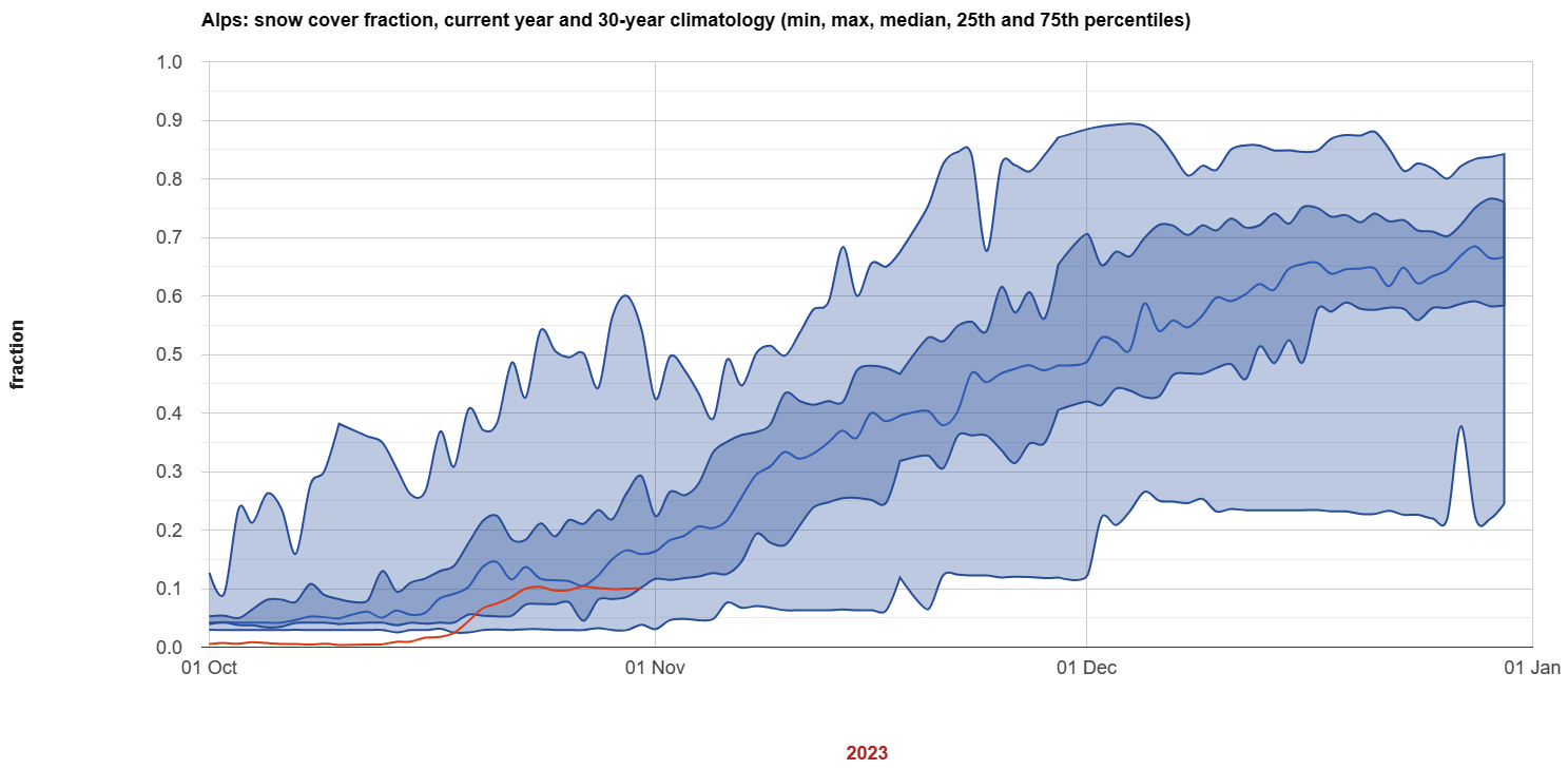
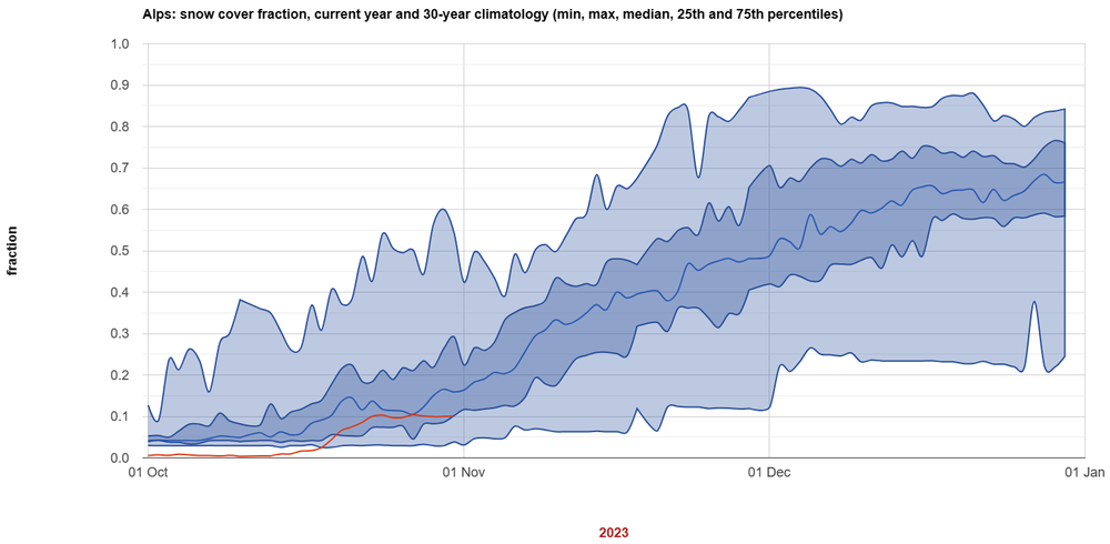
Cela fait penser à Alps Snow Monitor de Simon GASCOIN : https://sgascoin.users.earthengine.app/view/alps-snow-monitor-30y-catchments
-
Suivi du temps dans le Sud-Ouest - Novembre 2023
Thundik81 a répondu à un sujet de pim82 dans Le temps en France
Andreu Gómez Simón (mail en gmail tout attaché et sans diacritiques) proposait cela sur son Meteopireneu : http://web.archive.org/web/20220125114801/http://meteopirineu.com/estacion/station2.html Le vrai LiDAR HD c'est là : https://geoservices.ign.fr/lidarhd -
Verkís avait modélisé cela comme protection autour de Svartsengi : https://www.ruv.is/frettir/innlent/2023-11-08-varnargardar-vid-svartsengi-teiknadir-upp-396053 [Info : Spegillinn du 06/11/2023] + Voir aussi : https://www.mbl.is/frettir/innlent/2023/11/08/2_5_3_milljardar_svona_yrdu_varnargardarnir/
-
Suivi du temps dans le Massif Central - Novembre 2023
Thundik81 a répondu à un sujet de damien63 dans Le temps en France
Ce matin juste après mon message, j'avais vu cet article : https://www.leveil.fr/langogne-48300/actualites/alerte-sur-le-niveau-tres-bas-de-naussac_14400475/ -
La Protection civile refait sa page sur les éruptions : https://www.almannavarnir.is/natturuva/eldgos/
-
Point du jour de l'IMO : https://www.vedur.is/um-vi/frettir/jardskjalftahrina-nordan-vid-grindavik-hofst-i-nott > https://www.vedur.is/media/bylgjuvixlm-8-nov-uppfaerd.png
-
Suivi de l'englacement au pôle nord
Thundik81 a répondu à un sujet de sirius dans Evolution du climat
MILLAN, JAGER, MOUGINOT et al. - Rapid disintegration and weakening of ice shelves in North Greenland (Libre accès) < https://www.ige-grenoble.fr/Vers-une-disparition-complete-des-dernieres-plateformes-flottantes-du-Groenland -
Suivi du temps dans le Massif Central - Novembre 2023
Thundik81 a répondu à un sujet de damien63 dans Le temps en France
Le tour de passe-passe classique : Considérant que ce débit d’objectif moyen journalier de 5,5 m³/s fixé du 15 mai au 15 septembre à la confluence de l’Allier et du Chapeauroux, était lié à l’ancienne gestion du barrage de Poutès et qu’il ne répond pas aux besoins des enjeux prioritaires. (Arrêté préfectoral nº DDT-BIEF-2023-131-0001 en date 11 mai 2023 portant autorisation de déroger au respect du maintien du débit d’objectif a la confluence de l’Allier et du Chapeauroux depuis le barrage de Naussac situé sur la commune de Naussac-Fontanes) [souvenirs de ta visite à Poutès] Y'a la mise en place d'une commission, autre grand classique : Arrêté interpréfectoral n° DDT-BIEF-2023-269-0001 du 26 septembre 2023 relatif à la commission de suivi des aménagements liés au barrage réservoir de Naussac (Préfectures de la Lozère et de la Haute-Loire). Toujours regarder les RAA pour plus d'infos. -
Record de connectés sur Infoclimat
Thundik81 a répondu à un sujet de Clim@ dans Vie du site Infoclimat
Tous ces visiteurs qui pourraient être des adhérents : de quoi donner le tournis au trésorier -
Le vent est un des paramètres les plus difficiles à comparer entre stations (= lieux de mesure). Le matériel de mesure est secondaire. Voir par exemple la Note 39 : https://www.infoclimat.fr/stations/DSO_ENR_OBS_Note39.pdf