_Joel_
-
Compteur de contenus
645 -
Inscription
-
Dernière visite
Type de contenu
Profils
Forums
Calendrier
Tout ce qui a été posté par _Joel_
-
Tu peux utiliser le logiciel iSpy par exemple A cette adresse, tu trouveras des infos sur la manière de recevoir une image de ta caméra : http://www.ispyconnect.com/man.aspx?n=Foscam
-
http://global.oregonscientific.com/manual/WMR86.pdf Pages 27 et 28 : " RÉGLAGE DU PLUVIOMÈTRE " Tu as bien respecté tous les points ?
-
Ca vaut mieux que l'inverse
-
En tout cas, les répéteurs sans fil sont toujours au catalogue 2018 de Davis : Page 13 pour ceux que ça intéresse : https://www.davisnet.com/product_documents/weather/Catalogs_Brochures/Weather_Catalog.pdf Deux modèles sont présentés : 7654 Long-Range Repeater, Solar-Powered $300 7627 Standard Wireless Repeater, Solar-Powered $250 Par contre plus aucune trace du modèle avec alimentation électrique
-
Ca discute ferme sur l'API à cette adresse : http://www.wxforum.net/index.php?topic=33601.0
-
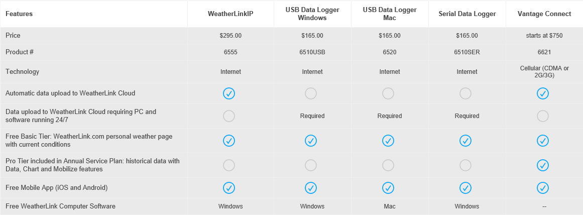
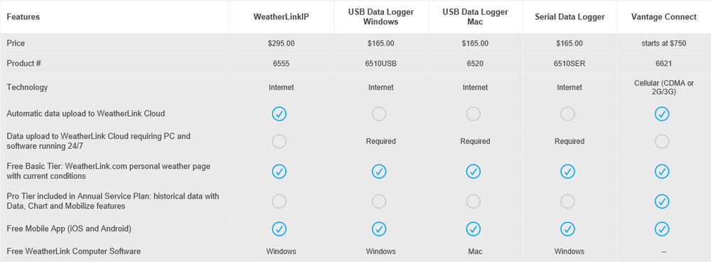
Avec le datalogger IP, tu avais le droit de publier des données sur le site WL. Avec WL 2.0, tout le monde a droit à un accès de base gratuit, pas uniquement les DL IP Plus d'infos ici :
-
Je suppose que par "licence" tu parles de la possibilité d'envoyer les données sur le site weatherlink.com ? Avec son nouveau site "WeatherLink.com 2.0", Davis a revu entièrement sa politique en la matière. L'accès de base est gratuit mais ne permet de consulter que les données actuelles L'accès "pro" coûte 3,95$ / mois et permet en plus de consulter l'historique (données, graphiques) https://www.davisnet.com/weatherlink/#wlpricing
-
Il y a un problème sérieux chez Weather Underground depuis 3 ou 4 jours. Si tu as un problème uniquement avec eux, ça ne vient pas de toi.
-
Ce n'est pas tout à fait exact. Un câble de 12 m est fourni avec l'anémomètre mais on peut l'allonger. Davis vend des allonges à cet effet : 7876-008, 8' (2.4m) 7876-040, 40' (12m) 7876-100, 100' (30m) 7876-200, 200' (61m) Plus d'infos ici : http://www.davisnet.com/product_documents/weather/spec_sheets/7876_spec_4Con_Rev_D.pdf http://www.meteo-shopping.fr/Station-meteo/Cable-4-conducteurs-de-61-m-7876-200-Davis-Instruments
-
Comme tu as certainement pu le lire sur le forum dédié à Cumulus, son développeur est pensionné et s'est acheté un motorhome avec lequel il parcourt l'Europe. Pour l'instant il se trouve au Portugal. Je te laisse lire sa conclusion, elle date du 13 août 2017 : "Note that this means that it is highly unlikely that there will be any updates to Cumulus for the foreseeable future, or perhaps ever - sorry."
-
Sans fil : - installation plus facile - capteurs additionnels en option - risque réduit de dommages dus à la foudre (source : Davis)
-
Transmettre, oui , mais encore faut-il pouvoir les consulter Voici la description de WLIP : WeatherLinkIP is “plug-and-play” – there is no annual subscription to upload your data to the WeatherLink Cloud and start enjoying viewing your current conditions anywhere & anytime. Tout est dans le "current". Dans la description de Weatherlink 2, Davis fait bien la différence entre les données en cours (bulletin et carte) qui sont gratuits, et l'historique qui est payant. Bulletin with Current Conditions (FREE!) Build and customize your bulletin dashboard to receive current data updates from all of your installed sensors. You can move and resize tiles to see the data just the way you like it. Chart Visualize any of your sensor data with custom line and bar charts on up to 4 different y-axes. Zoom into an hour of data or out to a full year to view details and trends. Data Access all of your raw sensor data at the click of a button. You can sort by date/time or data type and export any data set directly to an Excel-friendly .csv file. Map (FREE!) Use the WeatherLink Map to view and interact with the community of public stations in the worldwide WeatherLink Network. Click on a station to see a summary of current data and click the bulletin to see the station’s customized weather dashboard. Mobilize Use the Davis Mobilize App on iOS or Android to create custom frost, weather, crop and irrigation views for web and mobile. It’s powerful enough to help avoid losing your farm crop to frost, and fun for the data-savvy backyard gardener looking to perfect their tomato crop.
-
J'ai trouvé ces quelques articles dans leur FAQ : How can I show my data on my personal website? Do you have an API or a widget option? Yes. We are building an API for you, which will be available by Q2/2018. How many devices can I register under one account on WeatherLink.com 2.0? As many as you want. You can register unlimited amount of devices and have access to their current conditions (Bulletin). With the Pro Tier plan, you are able to access and use advanced features for 3 of your devices. Note: Vantage Connect and EnviroMonitor owners are automatically on Pro Tier plan. How do I share my data with my family, friends or neighbors? WeatherLink.com 2.0 A sharing feature will be implemented by Q2/2018. Meanwhile, if your weather station is set for public sharing (Device > Device Info > Weatherlink Network > Public), you can share the URL to your current conditions Bulletin with your family, friends and neighbors. As long as they are registered with a WeatherLink.com 2.0 account, they can view your data. WeatherLink Mobile App Have your family, friends or neighbors download the app and create a WeatherLink account. You can either share a link to your weather station, or they can search for your station name or location on the map. With a simple click on the ‘Add Station’ button, your weather station will be added to their list of stations on their home screen. Is there a cost to share data or view others’ data? No. Once the sharing feature on WeatherLink.com 2.0 is implemented in Q2/2018, it will be free of charge. Sharing your weather station data publicly as a member of WeatherLink Network is also free of charge, as well as viewing any current condition data from other publicly-shared stations on the map.
-
Même constatation. Je viens de chatter avec le support technique de Davis à ce sujet. Ils doivent me recontacter par email
-
Oups, je n'avais pas mis ce sujet à jour ... Le 12 décembre, j'ai reçu l'email suivant : Aux membres de notre communauté webcam: Beaucoup d'entre vous nous ont dit combien vous appréciez et comptez sur notre produit webcam. Nous n'arrêterons donc pas le produit comme nous l'avons déclaré en novembre. Nous continuerons d'autoriser les utilisateurs à ajouter des webcams au réseau Weather Underground et tout le monde pourra voir les images des webcams connectées. Nous vous remercions de votre soutien passionné et nous excusons pour tout désagrément que nous avons causé.
-
J'avais demandé de la neige mais je n'ai reçu que de la grisaille
-
Durée de vie moyenne d'une carte SIM de VP2.
_Joel_ a répondu à un sujet de Aurélien38 dans Instrumentation
Je ne suis jamais passé au firmware 3.x parce que j'avais lu à l'époque des messages relatant une incompatibilité avec VVP -
Bonsoir, Il y a sur cette page un article concernant une mise à jour de weatherlink.com http://www.weatherstations.co.uk/weatherlink-com-2-0.htm et accessoirement l'arrêt du développement de weatherlink. Bon, de toute façon, ils avaient arrêté depuis bien longtemps ...
-
Heu, mais je le sors du lien que tu as posté : http://www.weatherlink.com/xml.php?user=dfgdgfdfg&pass=54646456 A la première ligne du fichier XML obtenu par ce lien, tu trouves le lien vers la description du contenu : <current_observation version="1.0" xsi:noNamespaceSchemaLocation="https://s3.amazonaws.com/static.weatherlink.com/noaa_davis_current_observation.xsd"> Si tu prends la peine de le consulter, tu trouveras la liste de tous les éléments possibles du fichier XML et leur format. Par exemple (que j'ai posté plus haut) : <xsd:element type="xsd:decimal" name="uv_index" minOccurs="0" /> L'élément s'appelle "uv_index" et est de type "decimal". minOccurs="0" indique qu'il est facultatif.
-
Tu as essayé ceci ? <xsd:element type="xsd:decimal" name="uv_index" minOccurs="0" /> <xsd:element type="xsd:decimal" name="uv_index_day_high" minOccurs="0" /> <xsd:element type="xsd:string" name="uv_index_day_high_time" minOccurs="0" /> <xsd:element type="xsd:decimal" name="uv_index_month_high" minOccurs="0" /> <xsd:element type="xsd:decimal" name="uv_index_year_high" minOccurs="0" />
-
Si tu as l'esprit tordu, tu renvoies le datalogger en disant qu'il ne te convient pas et tu en achètes un autre au prix promotionnel Plan B : tu les contactes et tu leur demande de t'accorder la promotion.
-
Heu, où vois-tu un port USB ?
-
VP2 Sud de Gourdon 46300 dans le Lot
_Joel_ a répondu à un sujet de Tony du Lot dans Instrumentation
Je te conseille quand même d'envisager un modèle PoE et d'acquérir un switch PoE pour les alimenter. -
Et voici la confirmation officielle : "WU says goodbye to Webcams" http://help.wunderground.com/knowledgebase/articles/1821811-wu-says-goodbye-to-webcams
-
Lu sur le forum wxforum.net : My webcam had been updating perfect since 10/23/17. This morning it stopped updating at 3:38AM MST. I emailed support and Jeff Masters as my usual during the problems of webcam updating started. At 10:25AM today I got an email from Jeff. "Hi David, thanks for all your reporting of issues with webcams over the past few months. Due to the difficulty we've had maintaining this feature, its negative ROI, and the downsizing of our staff, it has been decided to drop the webcam feature from WU on December 15. An announcement will go up on our webcam page on Wednesday. I'm sorry to see this feature go." Autrement dit, la fonctionnalité webcam disparaitra du site WU le 15 décembre, à la suite de difficultés techniques, retour négatif sur investissement et réduction de l'équipe.