
Sebaas
-
Compteur de contenus
26 559 -
Inscription
-
Jours gagnés
170
Type de contenu
Profils
Forums
Calendrier
Tout ce qui a été posté par Sebaas
-

Ouragan/TC Leslie --> Portugal!
Sebaas a répondu à un sujet de ribi dans Suivi des Phénomènes Cycloniques
Confirmation: -
Ouragan/TC Leslie --> Portugal!
Sebaas a répondu à un sujet de ribi dans Suivi des Phénomènes Cycloniques
Pour Weather Channel, transition post-tropicale faite. Il faudra attendre l'analyse du NHC pour valider officiellement cette info. -
Ouragan/TC Leslie --> Portugal!
Sebaas a répondu à un sujet de ribi dans Suivi des Phénomènes Cycloniques
Et bien regarde la légende de la carte NHC précédente - storm (tempête) puis dépression tropicale. -
Ouragan/TC Leslie --> Portugal!
Sebaas a répondu à un sujet de ribi dans Suivi des Phénomènes Cycloniques
Caractéristiques, oui, mais il n'était plus un ouragan depuis bien longtemps. -
Ouragan/TC Leslie --> Portugal!
Sebaas a répondu à un sujet de ribi dans Suivi des Phénomènes Cycloniques
https://www.public.nm.eurocontrol.int/PUBPORTAL/gateway/spec/index.html Sur les dernières images sat, et sans vouloir t'inquiéter, je me demande si ce n'est pas le scénario GFS qui prend le pas désormais... -
J'arrive 666ème! 🔥
-
Ouragan/TC Leslie --> Portugal!
Sebaas a répondu à un sujet de ribi dans Suivi des Phénomènes Cycloniques
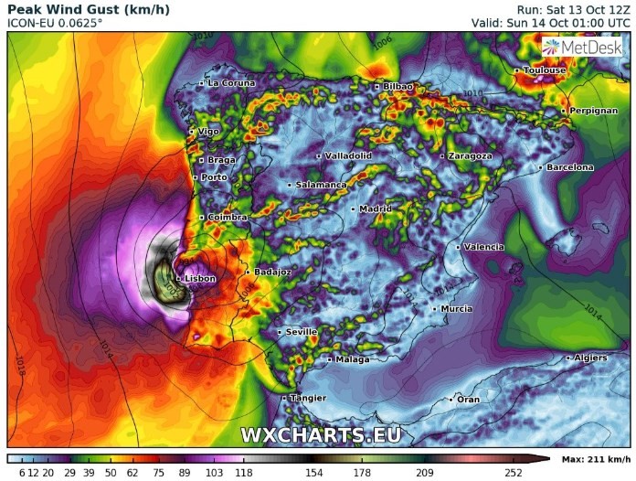
Ah ben @nicls est en France, comme l'essentiel des visiteurs de ce forum, donc je parle bien en heure de Paris. Voir d'ailleurs l'heure indiquée sur l'export Arpège. A noter que GFS décale nettement l'impact vers le Nord: Et ICON qui reste sur une trajectoire + Sud, mais maintient surtout son scénario hyper violent (rafales 200 km/h)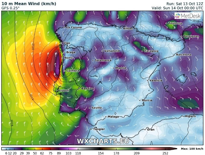
-
Ouragan/TC Leslie --> Portugal!
Sebaas a répondu à un sujet de ribi dans Suivi des Phénomènes Cycloniques
Début des hostilités vers 22h, paroxysme à 1h du matin (rafales 140, peut-être 150 km/h). -
Ouragan/TC Leslie --> Portugal!
Sebaas a répondu à un sujet de ribi dans Suivi des Phénomènes Cycloniques
La "Chaine météo" espagnole fait de Leslie le 1er ouragan a touché les côtes européennes 🤨 -
Ouragan/TC Leslie --> Portugal!
Sebaas a répondu à un sujet de ribi dans Suivi des Phénomènes Cycloniques
Hop, merci Aqua/Modis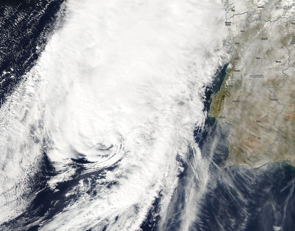
- 186 réponses
-
- 11
-

-

-
Suivi du temps dans le Nord-Ouest - Octobre 2018
Sebaas a répondu à un sujet de Romain56 dans Le temps en France
Topic de suivi et non prévi SVP. -
Ouragan/TC Leslie --> Portugal!
Sebaas a répondu à un sujet de ribi dans Suivi des Phénomènes Cycloniques
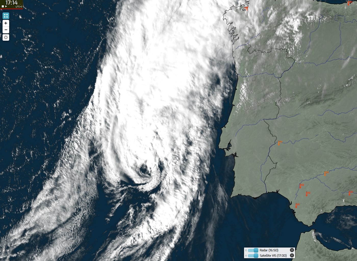
Presque un oeil sur les dernières images sat' - en tout cas toujours de la convection dans la partie Nord du système.
-
Ouragan/TC Leslie --> Portugal!
Sebaas a répondu à un sujet de ribi dans Suivi des Phénomènes Cycloniques
Elle a la peau dure malgré une eau à 20°C... Dommage pour la fauchée MODIS Terra, qui la coupe en 2. Espérons qu'Aqua ou Suomi NPP auront plus de chance dans quelques heures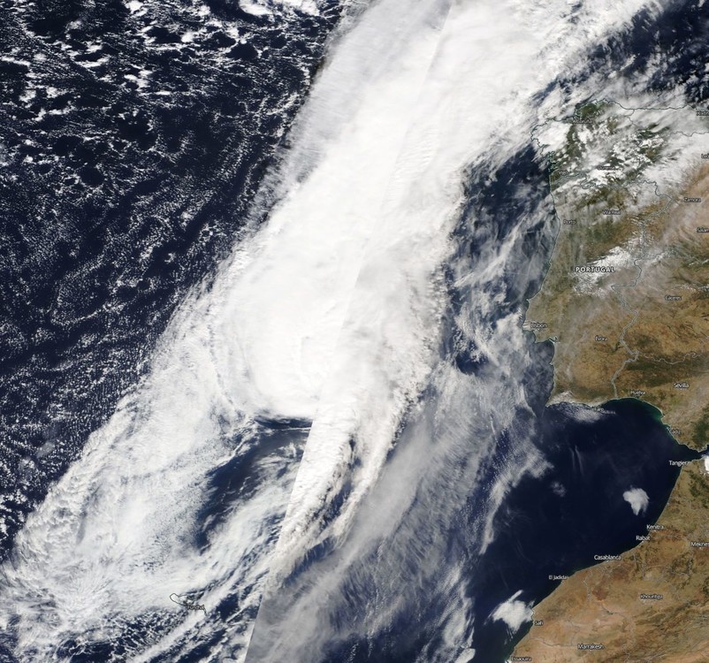
-
Ouragan/TC Leslie --> Portugal!
Sebaas a répondu à un sujet de ribi dans Suivi des Phénomènes Cycloniques
Et il faudra suivre la SYNOP du cap Carvoeiro ( https://www.infoclimat.fr/observations-meteo/temps-reel/cabo-carvoeiro/08531.html ) ainsi que la StatIC d'Alcobaça en effet ( https://www.infoclimat.fr/observations-meteo/temps-reel/alcobaca/000EX.html ) Également: http://www.ipma.pt/en/otempo/obs.superficie/#Santa Cruz (Aerodromo) http://www.ipma.pt/en/otempo/obs.superficie/#Lisboa (G.Coutinho) Radar: http://www.ipma.pt/en/otempo/obs.radar/ -
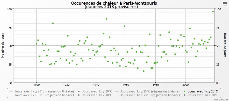
Aujourd'hui, 95 ème jour de 2018 avec Tx>= 25°C sur Paris : https://www.infoclimat.fr/climatologie/annee/2018/paris-montsouris/phenomenes/07156.html Le 96 ème très probable demain, et qui posera a priori définitivement (mais sait-on jamais après cette été de dingue?!) là le record de jours de chaleur à Montsouris avec 9j de + que le précédent record de 1947 (pour une normale annuelle de 49j...)
- 220 réponses
-
- 5
-
-

-
- températures
- estivales
- (et 2 en plus)
-
Ouragan/TC Leslie --> Portugal!
Sebaas a répondu à un sujet de ribi dans Suivi des Phénomènes Cycloniques
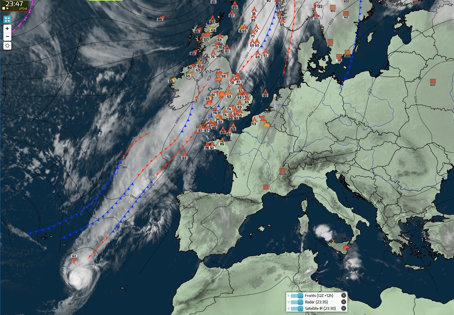
Leslie aura bien voyagé et donnait du fil à retordre aux modèles et prévis du NHC en tout cas : https://www.nhc.noaa.gov/archive/2018/LESLIE_graphics.php?product=5day_cone_with_line Analyse MF inhabituelle avec 2 ex-ouragans sur l'Europe occidentale: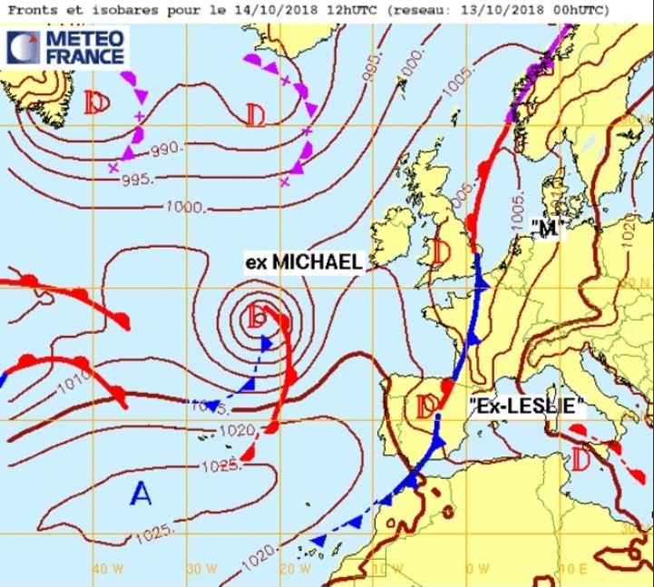
-
Ouragan/TC Leslie --> Portugal!
Sebaas a répondu à un sujet de ribi dans Suivi des Phénomènes Cycloniques
Mesoscale Discussion Estofex http://www.estofex.org/cgi-bin/polygon/showforecast.cgi?text=yes&fcstfile=2018101321_201810131000_0_mesoscalediscussion.xml Mesoscale Discussion Valid: Sat 13 Oct 2018 09:00 to Sat 13 Oct 2018 21:00 UTC Issued: Sat 13 Oct 2018 10:00 Forecaster: ESTOFEX This is a Mesoscale Discussion issued for a cyclone that is primarily driven by convection. This Mesocale Discussion is not an official product and does not substitute any warnings from National Meteorological Services. We welcome any feedback at inflow@estofex.org. System: 2018A01, Leslie At 13 OCT 0900 UTC the storm was located at 36.6N and 16.5W Estimated minimum pressure: 978 mb. Maximum sustained winds: 35 m/s (70 kt, 120 km/h). Maximum gusts: 45 m/s (90 kt, 165 km/h). ANALYSIS At 09 UTC, Leslie was quickly moving east-northeastward with a well-established central dense overcast and a marginal hurricane with sustained winds near 70 kt. A number of convective bursts have been visible near the core in the last hours, and the intensity seems to keep steady. Leslie is located right ahead of a surface cold front and some of the drier air from the northwest is wrapping along the southern flank of the storm. FORECAST The track forecast follows the ICON-EU and ECMWF forecasts closely, rather than the GFS 00 UTC run which has a more southerly track, as it appears that the cyclone follows the track predicted by the former two models rather than the southern one of GFS. This track brings Leslie to the Portuguese coast some 150-200 km north of Lisbon, (near Leiria) between 21 and 00 UTC. Prior to landfall, from approximately 18 UTC onward, Leslie should start to strongly interact with the cold front. As a result, most higher resolution models expect a strengthening of the surface wind field on Leslie's western and southern flank. It is expected that areas just south of Leslie's core will experience the strongest winds. Wind gusts in the range of 40 – 50 m/s (145 - 180 km/h) are simulated in this area. A larger region will experience wind gusts in excess of 33 m/s (120 km/h). The rainfall and flash flood risk with Leslie is relatively benign, as most rainfall is expected to fall in an area of isentropic ascent on the northwestern flank of Leslie as a result if its interaction with the cold front. Most of this precipitation will therefore fall over sea. Across northern and central Portugal accumulations of 30-60 mm will nevertheless be possible. Latest model guidance suggests that the risk of tornadoes over land will be low, as there should be little to no surface-based instability in areas with strong low-level wind shear. A minimal risk may exist to the north and east of Leslie's core. Forecast track: FH DATE & TIME LOCATION PRESSURE WIND MAX.GUSTS 00 13OCT 0900 UTC 36.6N 16.5W 978 mb 35 m/s 45 m/s 03 13OCT 1200 UTC 37.2N 14.8W 980 mb 33 m/s 45 m/s 09 13OCT 1800 UTC 38.5N 11.7W 982 mb 33 m/s 50 m/s 15 14OCT 0000 UTC 39.8N 8.7W 985 mb 33 m/s 50 m/s ... INLAND 21 14OCT 0600 UTC 41.8N 6.8W 997 mb 17 m/s 22 m/s ... INLAND 27 14OCT 1200 UTC ... DISSIPATED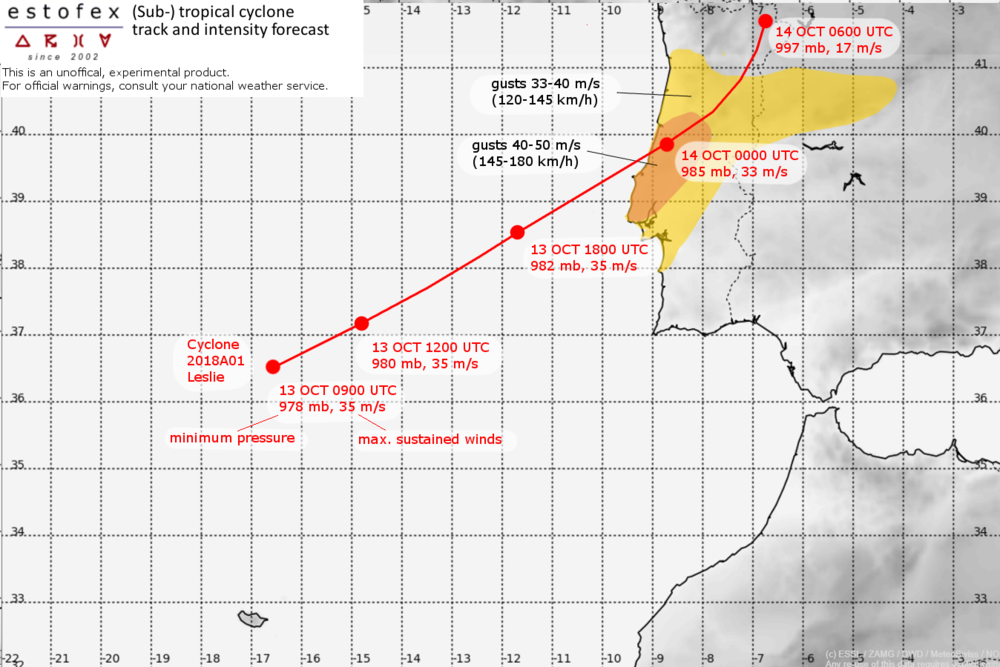
-
Ouragan/TC Leslie --> Portugal!
Sebaas a répondu à un sujet de ribi dans Suivi des Phénomènes Cycloniques
Arpège varie sur l'intensité (rafales qui approchent les 150 km/h sur ce run) mais reste quand même hyper stable sur la trajectoire. -
Ouragan/TC Leslie --> Portugal!
Sebaas a répondu à un sujet de ribi dans Suivi des Phénomènes Cycloniques
Et niveau 3 chez Estofex : http://www.estofex.org/cgi-bin/polygon/showforecast.cgi?text=yes&fcstfile=2018101406_201810122345_3_stormforecast.xml -
Ouragan/TC Leslie --> Portugal!
Sebaas a répondu à un sujet de ribi dans Suivi des Phénomènes Cycloniques
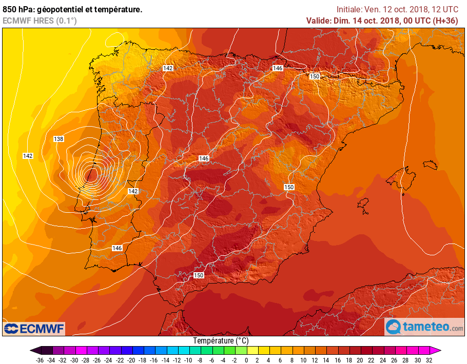
Arpège 18Z, Lisbonne pleine balle. Rafales 140 km/h -
Ouragan/TC Leslie --> Portugal!
Sebaas a répondu à un sujet de ribi dans Suivi des Phénomènes Cycloniques
Pour le moment c'est calme plat pour le Portugal: http://www.ipma.pt/pt/otempo/prev-sam/timeline.jsp?reg=LSB L'AEMET communique http://www.aemet.es/documentos_d/enportada/20181012120950_p52tesp1.pdf -
Ouragan/TC Leslie --> Portugal!
Sebaas a répondu à un sujet de ribi dans Suivi des Phénomènes Cycloniques
Bon je m'autocite et je floode je sais, mais la lecture de ce tweet relativise clairement l'affirmation précédente... -
Ouragan/TC Leslie --> Portugal!
Sebaas a répondu à un sujet de ribi dans Suivi des Phénomènes Cycloniques
Et donc comme on m'a fait remarquer que j'avais publié le 0Z de CEP mais pas le 12Z nettement plus péchu en effet (mais la carte n'était pas encore sortie sur tameteo.com)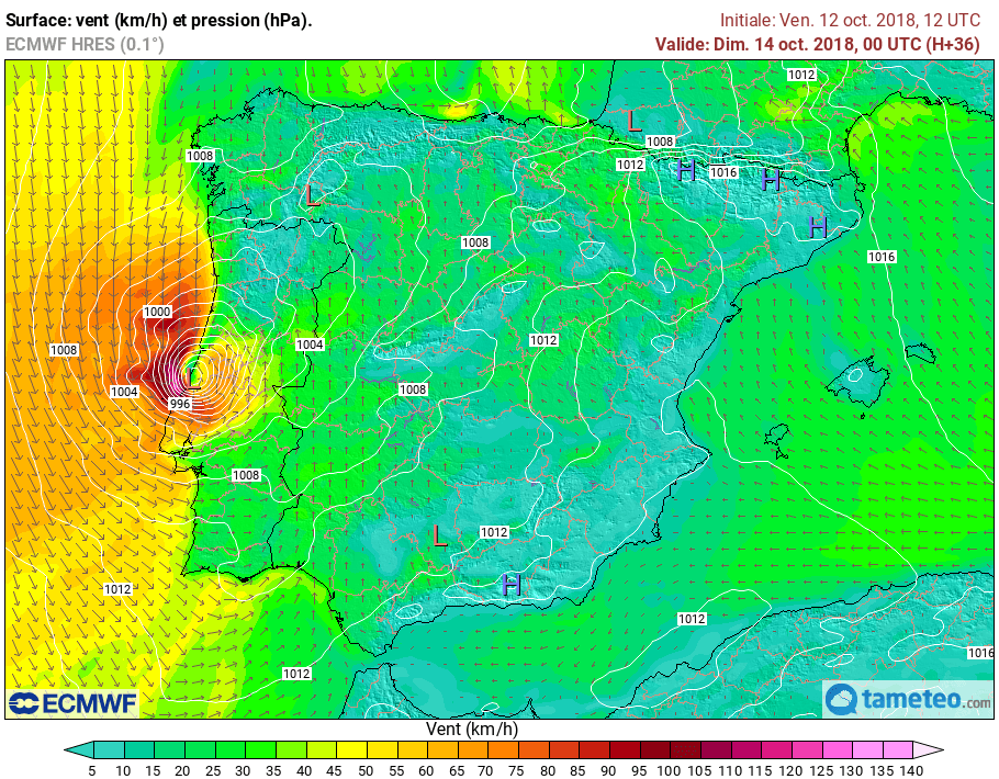
-
Ouragan/TC Leslie --> Portugal!
Sebaas a répondu à un sujet de ribi dans Suivi des Phénomènes Cycloniques
Au niveau ouragan en terme de vitesse de vent, mais a priori la transition extra-tropicale est bien prévue demain samedi dans la journée. Enfin, on va retrouver des images sat' qui rappelle l'an dernier à la même époque avec Ophélia!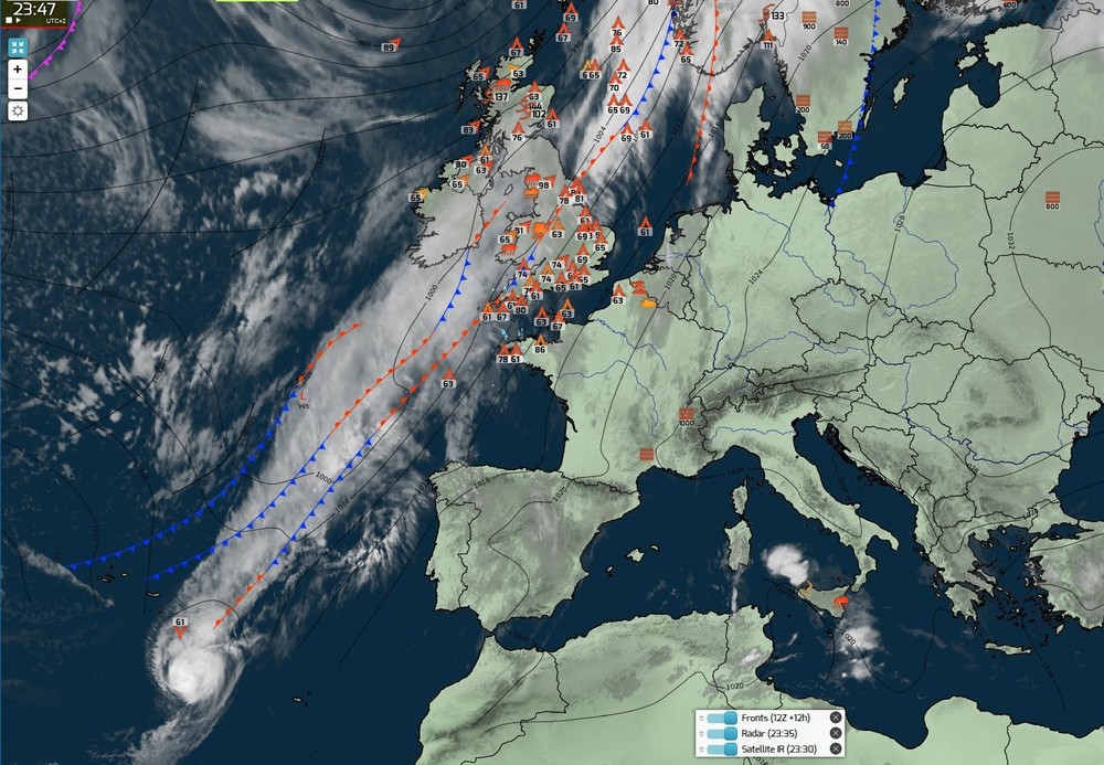
-
Du 15 octobre au 21 octobre 2018 - prévisions météo semaine 42
Sebaas a répondu à un sujet de sebinnis dans Evolution à plus long terme
Ouais ou sinon directement sur le forum (mêmes cartes, même avatar! mais surtout avec le texte )